Austin Area Flooding

Devilman

Well-known member
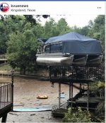
All our Austin area folks hope ya'll are staying safe!

Live feed of the water going over one of the dams... Crazy amount of water. Seen a couple boats go over already...  Max Starcke Dam in Marble falls, which it's overflowing into Lake Travis.

https://www.kxan.com/weather/forecast/todays-forecast/1010837543
 

Devilman

Well-known member
FM 2900 bridge over the Llano River in Kingsland washed out....

https://cbsaustin.com/news/local/video-catastrophic-flooding-on-llano-river
 

customtouch

Active member
If you think it is crazy to hear about it, you should see it. I was helping a buddy with a marina move and shuffle things all day and till 3am. Travis was coming up a little over a foot and a half an hour. The drystack where my boat was is on top of a pretty big hill but we couldn't get all the boats on the bottom row moved out in time. I am guessing by now they are floating. I got mine out and moved way up the hill at another buddies shop around noon yesterday before things got hairy. On my way back now to help again.
 

Devilman

Well-known member
damn David, ya'll be careful out there. Saw this posted on RD's about it earlier this morning...

"Lake Travis is officially 127% full and still rising.

Many marinas including mine have been disconnected from shore because they are now floating so far away from it that most don't have gang ways long enough to reach anymore.

For those of you familiar with the old Carlos N' Charlies' the entire building is currently floating about 15ft above it's foundation"
 

Devilman

Well-known member
This is the thread where I found the original links.... there are also some pics taken by the poster over there.

https://www.riverdavesplace.com/forums/threads/major-flooding-in-texas-at-lcra-lakes.191311/
 

Disturbed

Active member
https://floodstatus.lcra.org/

Per the Flood Status Report:

Lake level forecast: Lake Travis is expected to rise to 705 to 710 feet msl by Friday, Oct. 19. No changes to current gate operations are planned at Mansfield Dam at this time. Forecasts for Lake Travis may rise with additional rainfall, upstream or downstream of Mansfield Dam. Dangerous fast moving water is flowing through Lake Travis.
Max Reading: 697.88 Oct 17 2018 1:15PM
Last Reading: 697.88 Oct 17 2018 1:15PM
 

Devilman

Well-known member
Saw this pic Greg posted on FB... That will be interesting getting that down. Makes ya wonder about all the ones washed away where they may end up.


Attachments

  • 44267095_2378255032190877_5410880965792759808_n.jpg
    44267095_2378255032190877_5410880965792759808_n.jpg
    112.4 KB · Views: 40

Patchman

Administrator
Staff member
A video of Marble Falls.
https://video.search.yahoo.com/yhs/search?fr2=piv-web&p=hill+country+flooding+today&hspart=att&hsimp=yhs-att_001#id=10&vid=567b4910f3a9dccb7139efc243d4c483&action=view

They launch off the road that the take out ramp is located! crazy.gif
That grassy lot is where the Lucas trailer would be setting!
 

Devilman

Well-known member
Wow! I saw this posted about Marble Falls... 

"For those who aren’t familiar with the area or the amounts of water that have come by so far. Yesterday Lake Travis added about 400000 acre feet of water. Most of that came through Lake LBJ, at the peak 350000 cfs was flowing through Marble Falls. For those who have been to boat race, the only things that wouldn’t be underwater would be the beer tent.

Lake Havasu holds 619000 acre feet, this could have filled it in a day and a half."
 

Patchman

Administrator
Staff member
Man that is some crazy water! Sad to see such a beautiful area devastated by flooding! Wish we had a race there this year! Don't look like there will be another one anytime soon! :smile25:
 

Devilman

Well-known member
Water like that is a powerful force. The flood here in '98 they called a 100 year flood... there are still areas that show the evidence or damage of it today.
 

Patchman

Administrator
Staff member
Yea, I was caught camping at New Braunfels once! It rained overnite, and the next morning we were stuck at the camp ground. After about 3 hours, the water went down and they let us out. That river was rising real fast. I was glad to get out of there! Fortunately we were at Lazy L&L. They are up on a hill. Some of the other camp grounds were wiped out. I think someone may have passed at Camp Beans. There was a tent there, but had caution tape around it and a bunch of police officers. That was the last of the tent camping there for us! crazy.gif
 

Devilman

Well-known member
I remember you talking about that in the past.


What about Tim... with all that water, it's gonna make it down to his neck of the woods at some point. Not sure how accurate it is,but saw this posted a bit ago.

"Mansfield Dam is planning to open all 8 floodgates to release water out of Lake Travis. This has never happened before. This means that property along Lake Austin (near Austin, Tx) will flood. The dam at Lake Austin will also be opened up to flow rates that will send enough water down the Colorado River to cause moderate flooding at #Bastrop #Lagrange #Columbus and #Wharton. If you live along the Colorado River be prepared to take action and stay close to the forecast"


Disturbed

Active member
Devilman said:
I remember you talking about that in the past.


What about Tim... with all that water, it's gonna make it down to his neck of the woods at some point. Not sure how accurate it is,but saw this posted a bit ago.

"Mansfield Dam is planning to open all 8 floodgates to release water out of Lake Travis. This has never happened before. This means that property along Lake Austin (near Austin, Tx) will flood. The dam at Lake Austin will also be opened up to flow rates that will send enough water down the Colorado River to cause moderate flooding at #Bastrop #Lagrange #Columbus and #Wharton. If you live along the Colorado River be prepared to take action and stay close to the forecast"

Just a trickle compared to what we got here last year from Harvey.  https://water.weather.gov/ahps2/hydrograph.php?wfo=ewx&gage=cbst2&hydro_type=2  I think they considered the flood from Harvey a 500 year event.  There's some interesting data on the page on this link.  "Historic" and "Recent" crests.
 
Top